• Skip to primary navigation
  • Skip to main content

Millburn-Short Hills Historical Society

  • About
    • Trustees
  • Explore
    • The Archive
    • The Map Room
    • The Thistle
  • Community Projects
    • Virtual Walking Tours
    • Historical Interviews
    • Special Places Reports
  • Exhibitions
    • Millburn and The Civil War
  • News
  • Become a Member
  • Donate
  • About
    • Trustees
  • Explore
    • The Archive
    • The Map Room
    • The Thistle
  • Community Projects
    • Virtual Walking Tours
    • Historical Interviews
    • Special Places Reports
  • Exhibitions
    • Millburn and The Civil War
  • News
  • Become a Member
  • Donate

Archive Entry

Archive Entry

Go back
Prev Item Next Item

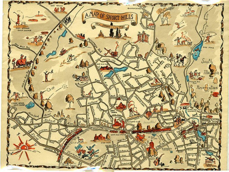
Map: 1936 Colored Map of Short Hills

Map
Colored (hand-colored?) print of 1936 map of Short Hills drawn by Bennett Durand. Map features figural representations of town features, such as clubs, houses of worship, schools, recreational activities, etc.. Map has edge wear, yellowing on all edges, ca. 1/4" tears along edges, vertical crease top to bottom in the center of the map, bluish color in the center back of the map, and a ca. 1" tear at the center top of the map. The lower right hand corner of the back has "Carolyn" written in pencil.

2015.013.016

1936

15-1/2 in

12-1/4 in
         Map: 1936 Colored Map of Short Hills picture number 1

PO Box 243 | Short Hills, NJ 07078 | phone: (973) 327-3258 | email: info@mshhistsoc.org PO Box 243
Short Hills, NJ 07078
phone: 973-327-3258
© 2026 The Millburn–Short Hills Historical Society | Privacy Policy
Website Designed and Developed by New Frontier, Millburn NJ