• Skip to primary navigation
  • Skip to main content

Millburn-Short Hills Historical Society

  • About
    • Trustees
  • Explore
    • The Archive
    • The Map Room
    • The Thistle
  • Community Projects
    • Virtual Walking Tours
    • Historical Interviews
    • Special Places Reports
  • Exhibitions
    • Millburn and The Civil War
  • News
  • Become a Member
  • Donate
  • About
    • Trustees
  • Explore
    • The Archive
    • The Map Room
    • The Thistle
  • Community Projects
    • Virtual Walking Tours
    • Historical Interviews
    • Special Places Reports
  • Exhibitions
    • Millburn and The Civil War
  • News
  • Become a Member
  • Donate

Archive Entry

Archive Entry

Go back
Prev Item Next Item

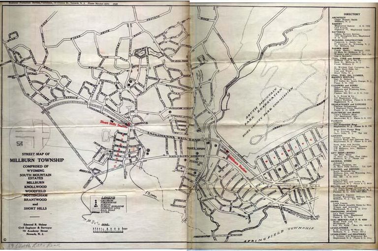
Map: Street Map of Millburn Township, 1929

Map
Business promotion map of Millburn, Short Hills and Wyoming district dispensed by Mansfield & Swett, Inc. at the Depot Plaza, Maplewood, NJ. Picture illustrates the map area. Reverse features descriptive text and a map of New Jersey with major thoroughfares from Pompton to Ledgewood to Princeton to Bayhead. Copyright Business Promotion Service, Newark, NJ Map folded in half (8.5 x 11), again folded in half (5.5 x 8.5) and then into pocket-size (+/-2.75 x 8.5) although this is across printing.

2007.035.001

2007.035

1929

11 in

17 in
         Map: Street Map of Millburn Township, 1929 picture number 1

PO Box 243 | Short Hills, NJ 07078 | phone: (973) 327-3258 | email: info@mshhistsoc.org PO Box 243
Short Hills, NJ 07078
phone: 973-327-3258
© 2026 The Millburn–Short Hills Historical Society | Privacy Policy
Website Designed and Developed by New Frontier, Millburn NJ