• Skip to primary navigation
  • Skip to main content

Millburn-Short Hills Historical Society

  • About
    • Trustees
  • Explore
    • The Archive
    • The Map Room
    • The Thistle
  • Community Projects
    • Virtual Walking Tours
    • Historical Interviews
    • Special Places Reports
  • Exhibitions
    • Millburn and The Civil War
  • News
  • Become a Member
  • Donate
  • About
    • Trustees
  • Explore
    • The Archive
    • The Map Room
    • The Thistle
  • Community Projects
    • Virtual Walking Tours
    • Historical Interviews
    • Special Places Reports
  • Exhibitions
    • Millburn and The Civil War
  • News
  • Become a Member
  • Donate

Archive Entry

Archive Entry

Go back
Prev Item Next Item

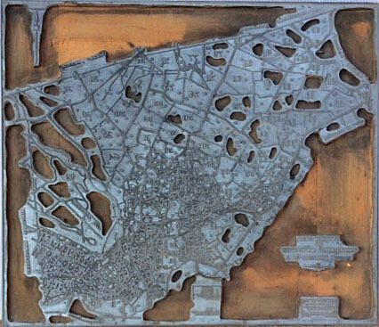
Map:1929 Printer's Plate Millburn Street Map

Object/Artifact
Galvanized metal (tin?) printer's plate of a 1929 street map of Millburn Twp.,which is nailed to a wood base. Donor indicated that it may be a tax map of Millburn Twp. Overall soiling of the wood on the front of the support. Circa 3-4 one-quarter inch losses to the metal. There is a map legend and a scale in the middle-bottom of the plate, and the plate on the lower right corner states: Made by, Edmund R. Halsey, Civil Engineer & Surveyor, 79 Academy Street, Newark N.J., ORDER No. 3130 March 1929.

2016.011.001

2016.011

24-1/2 in

21 in
         Map:1929 Printer's Plate Millburn Street Map picture number 1

PO Box 243 | Short Hills, NJ 07078 | phone: (973) 327-3258 | email: info@mshhistsoc.org PO Box 243
Short Hills, NJ 07078
phone: 973-327-3258
© 2026 The Millburn–Short Hills Historical Society | Privacy Policy
Website Designed and Developed by New Frontier, Millburn NJ